Hurricane Irma threatens to bring raging rains, towering storm surges and lingering flooding in low-lying areas to Florida as it inches closer. Nearly six million people have been ordered to evacuate the state, and almost every corner of it is expected to bear the storm’s impact.
There are many low-lying areas in South Florida. The tip of the state was only made habitable by water control, making the swampland sturdy enough to build on. Due to its warm weather almost all year-long, millions have decided to relocate to Florida as resorts and retirement communities also multiplied on the dried out land.
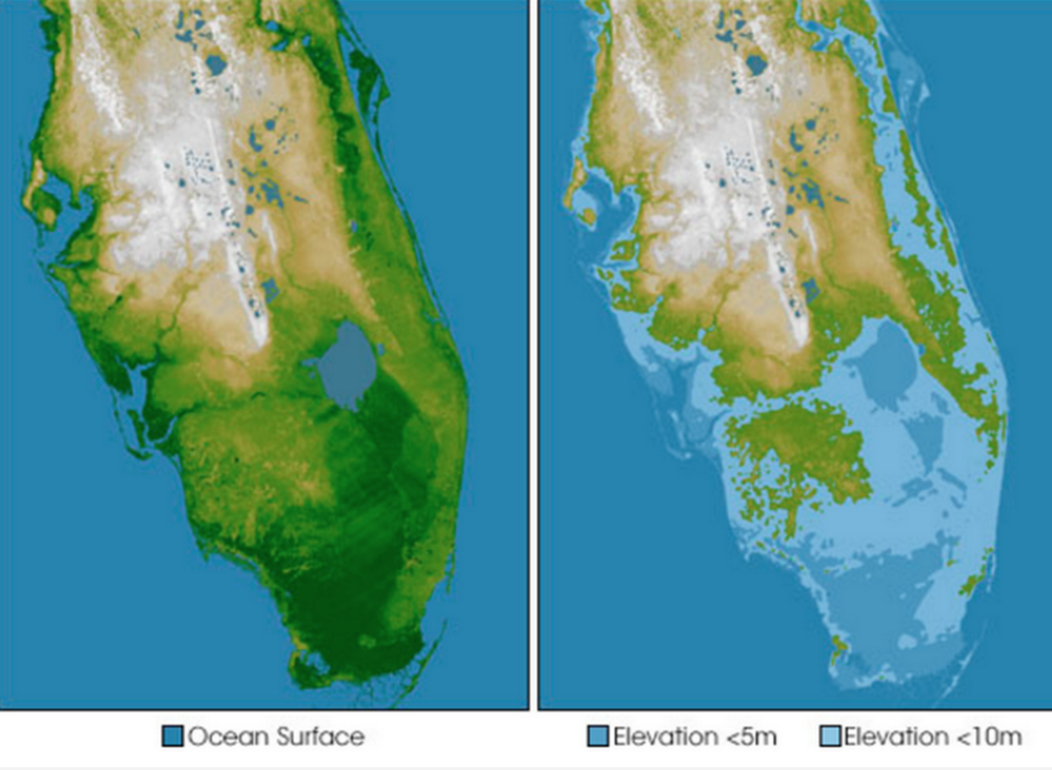
An alarming map from NASA, however, shows that humans won’t be able to control water levels in Florida forever. It would only take a few feet of sea level rise to put the southern part of the state completely submerged under water.
The map’s image on the left shows the elevation of Florida, with yellow being the highest and green being the lowest. (Even the highest elevation in the Sunshine state only maxes out at 197 feet above sea level.) The map on the left illustrates what will be left of Florida under 5 meters (about 15 feet) of water: Light blue states that areas that are only 10 meters above sea level, while the darker blue indicates areas 5 meters above sea level.
Miami, the Florida Keys, and the Everglades would be completely under water.
NASA collected the 3D measurements of Earth while on a space shuttle topography mission. NASA’s latest data reveals that sea levels have risen 3 inches since 1992, with a more dramatic rise of 9 inches seen in some parts of the globe. As sea levels continue to rise, that variation could persist.
A Category 4 storm (Hurricanes didn’t get names until 1953) in history killed 400 people in 1926 and another Category 4 killed 2,500 people two years after. The Army Corps of Engineers built the 85-mile long Herbert Hoover Dike. In 1948, Congress approved $208 million for the Central and South Florida Flood Control Project, which then built 16 major pumping stations and 1,700 miles of canals and levees. In more recent history, Hurricane Andrew ripped Miami to shreds in 1992. Building codes were strengthened and people quickly rebuilt homes and businesses in the same spots where they’d stood before the storm.
It is safe to assume then that no matter what devastation Irma may bring to Florida, people aren’t likely to move away
Source: http://www.sacbee.com/latest-news/article172347252.html
That looks like the map that Edgar Casey drew of the future America.
Anyone web surfing today will quickly see too many look alike comments and news articles.
It is clear the Far Left, lib's and MSM are desperate to tie Irma to Climate (cooling, warming, change, ) and / or Trump.
No matter how stupid the idea, it is all being floated …. just for some desperately needed deflection.